Fugro ROAMES Bringing Innovation to Energy Infrastructure
 By Conal Quinn | Journalist & Industry Analyst -
Tue, 09/20/2022 - 11:11
By Conal Quinn | Journalist & Industry Analyst -
Tue, 09/20/2022 - 11:11
Amid volatile energy prices and the push for greener practices, power companies are allocating greater investments to R&D to make their operations more efficient, economically viable and ecologically responsible. One subsector in particular, which is tipped to see significant growth in the coming years with an expanding number of suppliers active in the marketplace, is geodata. In the US alone, the geospatial market is projected to almost double in value, from US$59.5 billion to US$107.8 billion by 2026.
A major player pioneering innovation in the industry is Fugro, whose award-winning Remote Observation Automated Modeling Economic Simulation (ROAMES) technology, designed specifically for power utilities, creates a digital twin of such fidelity that it can be used for asset inspection, identification and condition assessment. Fugro ROAMES® offers a wide range of use-cases to clients, with value derived from cost-efficient features. These include up to 40 percent savings on vegetation management through desktop scoping, lowering the vegetation management cycle by one to two years and prioritizing critical clearances across the entire network.
What makes ROAMES a game changer, however, is that it eliminates the need to deploy inspection personnel to the field. The ROAMES digital twin allows operators and service companies to improve safety around their networks in the field, while reducing risk and total capital expenditure. The technology combines the most innovative geospatial mapping techniques with state-of-the art data processing and cloud computing capabilities to produce a meticulously precise digital twin of a power company's most valuable assets. Fugro, a designated AWS Energy Competency Partner, launched this first-of-its -kind revolutionary technology to the market in 2014, serving major distribution and transmission operators across Australia, the UK, Europe and North America ever since.
While many of the benefits of ROAMES are only just being understood and calculated since its adoption in other regions, its successful implementation has provided Fugro's clients with significant OPEX savings due to shorter inspection cycles and less boots-on-the-ground work. The improved asset management policies have also reduced the time lost to accidents and other preventable incidents. Moreover, since ROAMES provides improved predictive maintenance programming, this enables clients to determine if they need to replace assets or even prolong an asset’s life cycle through early intervention or preventative measures. In addition, CAPEX has been significantly reduced.
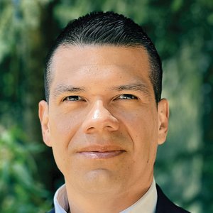
Fugro’s Global Commercial Excellence Manager Chris Boreland outlined how the company's product is streamlining geospatial solutions and enabling predictive programming to anticipate problems down the line. “ROAMES can be applied to digitization, digital twins and the monitoring of critical clearances around our clients’ assets. It provides our clients with the opportunity to move away from reactive asset management procedures to a proactive service, harnessing geospatial data at its core to make decisions in near real time and from the comfort of the office.”
One client that Fugro has helped to modernize its vegetation strategy is leading energy distributor Western Power Distribution (WPD), in the UK using lidar data gathered by its helicopter fleet. “The Fugro ROAMES 3D network model (digital twin) allows WPD to identify critical clearance issues such as ground clearances and vegetation intrusions to keep the network safe and operable throughout its life cycle. Fugro ROAMES uses cloud services to process, store and stream data analytics and visualizations to our clients,” said Boreland.
Traditionally, geospatial companies have focused on capturing and analyzing geospatial data to inform power companies' engineering design programs and support digital transformation with the integration of map records into a corporate Geographic Information System (GIS). However, the industry has tended to prioritize geospatial data acquisition and delivery while neglecting higher order data such as detailed asset measurements, condition assessment, vegetation growth or other analytics. All of this has changed over the past half decade as geospatial companies started to adopt a more sophisticated approach and began to develop additional services designed to provide more analytics from remote-sensing data, such as lidar and orthoimagery. While ROAMES clients can already make use of databases across their business from vegetation management to asset management and power flow monitoring, communication between these systems and their corporate GIS is more limited. The digital twin concept now provides the capabilities to align all these systems into a single asset, which twinned to the real-world asset allows for information to be shared across all areas of a business.
Furthermore, ROAMES is expected to play a leading role in modernizing the grid in anticipation of the eventual energy transition, as well as facilitating climate change adaptation and the construction of more sustainable infrastructure. With its “triple-A” approach, aimed at offering integrated data acquisition, analysis and advice, Fugro's digital twin solutions have allowed both marine and land clients to reduce their carbon footprint by moving away from traditional inspection programs to employ digital inspection programs, which merge disparate data sources to foster more informed decision making.
For instance, the physics-based, high accuracy 3D network model of a clients’ conductors and poles allows weather, network load and conductor material to be input and used to simulate the conductor sag and swing under different conditions. Together with a full-scale 3D network of a client's asset portfolio, Fugro also models the environment surrounding the assets, which can later be used to inform critical clearances, vegetation intrusions and the spatial accuracy of a clients’ GIS schematic. By providing these analytics, Fugro enables utility clients to implement digital inspection programs helping to reduce their carbon footprint, inspection cycles and OPEX costs.
In addition, Fugro has made available ROAMES World for visualization of the digital twin and ROAMES Analytics, which is required to improve asset measurement efforts and risk assessments. ROAMES World is a virtual world asset management platform built in the cloud – a high-performance 3D mapping environment that offers access to accurate, trustworthy and comprehensive information that helps understand real-world context and thereby facilitate more informed, efficient and easier management of assets.
With data records nearly in the millions, an asset register and any associated spatial data is typically too large to analyze at scale using traditional GIS or enterprise systems alone. As a result, it is difficult or impossible to detect broad trends, rapidly investigate an outlier or share access with users in any location. ROAMES addresses this need by offering a high-performance data investigation tool with a simple, intuitive interface. This allows users to obtain answers faster, which is critical for an optimized approach to asset and vegetation management. Maintaining conductor clearance is an important safety and compliance issue and by precisely managing and monitoring the location of assets in the ROAMES digital twin, power utility maintenance programs can be more effectively managed to mitigate risk.
Fugro is the world's leading geodata specialist. By continuing to evolve and improve the accuracy and speed of the data delivered to its clients, the company is well placed to remain at the forefront of the geospatial market. Just recently, Fugro has sought to harness the power of AI and cloud computing to fully automate and speed up its processes through digitization of its acquisition and processing workflows.
Fugro is the world’s leading Geo-data specialist, collecting and analyzing comprehensive information about the Earth and the structures built upon it. Adopting an integrated approach that incorporates acquisition and analysis of Geo-data and related advice, Fugro provides solutions. With expertise in site characterization and asset integrity, clients are supported in the safe, sustainable and efficient design, construction and operation of their assets throughout the full lifecycle
You May Like


Most popular