Data Accuracy Prevents Disaster: IDS GeoRadar


STORY INLINE POST


 By Fernando Mares | Journalist & Industry Analyst -
Mon, 10/27/2025 - 09:52
By Fernando Mares | Journalist & Industry Analyst -
Mon, 10/27/2025 - 09:52
Q: How does IDS GeoRadar engage with the mining industry in Mexico?
A: IDS GeoRadar provides leading radar technology and solutions that prioritize safety, reliability, and operational continuity. Through the Mexican office, we manage our specialized radar products across Mexico, Central America, the Caribbean, and parts of South America.
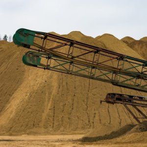
IDS’ radars are built for the mining industry but can also be used for civil projects. We can support projects of any scale, from a small quarry for a cement plant to a large open-pit mining operation. Our radar products are robust and complete, offering different ranges from a close 50m to the slope up to 5km. We install them to monitor the slopes of open-pits and tailings dams, as well as to monitor slope failure.
We are part of the Hexagon Corporation and its Geosystems division. Together with our sister company Leica Geosystems, our products make up the comprehensive portfolio of mine monitoring solutions. One key advantage is that IDS offers seamless integration with many software platforms and sensors, including Leica’s software, making our mine monitoring solution complete.
We stay connected to our customers, offering them 24/7 support, webinars, and annual training. We know that one of the toughest daily challenges they face is making difficult decisions that are 100% data-driven. They continuously need more reliable and better technology.
Q: What makes IDS GeoRadar a competitive player in the Mexican market?
A: Our company has provided advanced radar technology for more than 20 or 30 years and has been a pioneer in Synthetic Aperture Radar (SAR) technology for monitoring. IDS radars, the software we use, and the services we provide are all designed to enhance operational safety and risk management of slopes. Our technology is centered on interferometry measurement, Image By Interferometric Survey (IBIS), which provides continuous, non-stop, real-time monitoring of slopes. These measurements offer very high accuracy and precision over a wide or small coverage area as needed.
These capabilities allow geotechnical and geological departments to proactively address critical safety challenges, such as the risk of landslides or other slope failures in open pits, tailings dams, or quarries. Clients can take proactive measures, prevent accidents, protect lives, and minimize operational downtime and disruption. The radars are user-friendly, easy to install, deploy, and operate, and they function effectively in very challenging environmental conditions.
Q: Beyond preventing major disasters, how is your technology helping mine operators increase operational efficiency and productivity?
A: Choosing the wrong technology, or choosing nothing at all, can have significant financial consequences for mining companies where safety and efficiency are essential.
Some of the risks companies face include extended downtime periods; a less reliable radar is not efficient or fails constantly. They may also face higher maintenance costs. Unfortunately, some new technologies are poorly supported and deliver low-quality data. This requires frequent repairs and additional investment to maintain, resulting in a high long-term cost. The worst-case scenario, which we have seen occur, is the total loss of the initial investment in a low-quality system, resulting in wasted capital and the need for the company to invest again in a better solution. This represents a huge loss. As they say: buy cheap, buy twice.
Finally, one of the most important things in radar technology is data accuracy. If the radar does not work properly, the client will not have reliable or accurate data. This could lead to a total disaster because decisions are being made based on faulty information, resulting in operational disruptions and risks that were not detected. Data accuracy is a paramount component of this technology.
Q: How can emerging technologies like AI increase the performance of the products you already offer to the mining sector?
A: AI is the future, but it is also the present for many technologies. It holds great potential and acts as an added value to any system. Our company has been researching and investing in AI enhancements and implementations for several years. This is being done to improve predictive analytics and enhance data interpretation reliability. Furthermore, AI helps automate tasks and provide smarter alerts, which is particularly beneficial for users who manage large data sets, making their daily jobs easier.
Q: What is your long-term vision for the geophysical and real-time monitoring sector in Mexico, and what role does IDS GeoRadar have in that future?
A: We intend to continue the path of improvement, empowering mining and civil industries with top-tier technology. Mexico, in particular, presents a diverse landscape and unique challenges that demand constant innovation to meet customer needs. Therefore, the company will continue driving, innovating, and improving advanced radar-based monitoring systems. We will also maintain collaboration with industry leaders and academic institutions. Our ultimate vision is for Mexico to become a benchmark for innovation in geophysical monitoring and safety management, setting high standards for other countries in the region.
It has always been fulfilling to remain a step ahead, as that has been the way IDS has worked since the beginning. As I mentioned earlier, we were already pioneers in the monitoring technique we use.
Now, our focus is tightly coupled with AI and machine learning (ML). We are integrating these tools to improve the capabilities of all IDS products, both hardware and software. AI is a game-changer for all industries, including mining and geotechnical fields, because it allows us to process extremely large amounts of data. This yields more actionable insights in real time, leading to better decision-making for our customers.
IDS GeoRadar is an Italy-based provider of radar-based solutions for geophysical, mining, civil engineering, and security applications. The company is a pioneer in Ground-Penetrating Radar (GPR) and Interferometric Radar technologies that monitor millimetric movements in open-pit mines and critical infrastructure. As a part of the global Hexagon group, IDS GeoRadar sells its systems and provides data analysis and remote monitoring services worldwide.


Most popular